


Historic Nor’easter Bomb Cyclone Pummels Winston-Salem, Triad With Heavy Snow, Dangerous Travel and Widespread Disruption

Staff Report
The Winston-Salem Chronicle
A powerful nor’easter that underwent rapid intensification into a bomb cyclone off the North Carolina coast this weekend left a blanket of white across Winston-Salem and the Piedmont Triad, triggering perilous conditions, travel chaos and a community still digging out as bitter cold grips the region.
The storm, officially tracked as of January 30–February 1, 2026, and brought some of the heaviest snowfall in decades across central North Carolina — including into Forsyth County — transforming familiar city streets into snow-covered thoroughfares and prompting local officials to urge residents to stay off icy roads.
A Rare and Powerful Storm
Meteorologists characterize the system as a bomb cyclone — a rapidly intensifying low-pressure system that can deepen dramatically over a short period and produce extreme winter weather. This storm formed late Friday and intensified Saturday into Sunday, bringing heavy snow, gusty winds and dangerously low temperatures across wide swaths of the Southeast and mid-Atlantic.
Across the Carolinas, including areas near Winston-Salem, snowfall totals ranged widely, with some communities reporting more than a foot of accumulation from the storm’s strongest bands.
Roadway Hazards and Tragedy
In Charlotte and beyond, blizzard conditions and high winds converging with snowfall created treacherous road conditions. In a deadly reminder of the storm’s fury, a massive chain-reaction collision on Interstate 85 north of Charlotte left two people dead, confirmed by Governor Josh Stein during a Sunday news briefing in Raleigh, where he urged continued caution and patience as crews worked to clear highways and secondary streets.
While Forsyth County did not experience a crash of that magnitude, the area saw numerous spin-outs, stalled vehicles, and reports of stranded drivers, overwhelming local plow operations and delaying emergency response times. School districts and workplaces across the Triad, including in Winston-Salem, shifted to closures or remote operations as icy patches and drifting snow lingered into Monday.
Community Impact in Winston-Salem
Public works crews worked through the night into Sunday — in freezing conditions that kept temperatures well below average — applying sand and salt to priority roadways and responding to calls about blocked intersections.
“The city has never seen snow like this in recent memory,” one lifelong resident told The Chronicle.
Cold Weather, Power and Safety Concerns
Accompanying the snow was a deep Arctic cold front that plunged wind chills into dangerously low levels. Across the Carolinas and Southeast, cold weather advisories extended into the new week, raising concern for frostbite and hypothermia for anyone exposed without adequate protection.
County and city emergency management officials reminded residents that carbon monoxide poisoning risks can rise in winter storms when generators or space heaters are used indoors without proper ventilation.
What Comes Next
While the storm has moved on, freezing roads and lingering snow pack will continue to impact travel throughout the week. Road crews warn that untreated side streets may remain slick until repeated daytime thaw/freeze cycles allow safe plowing and melting.
Forecasters say the Arctic air mass is likely to persist, with potentially more flurries midweek as another weak system brushes the region. Residents are encouraged to continue checking weather alerts, plan for slow road conditions, and ensure adequate supplies should another weather system arrive.
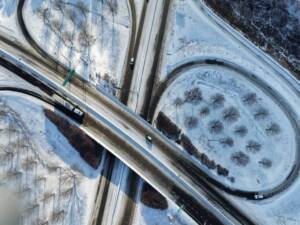
Salem Parkway and U.S. 52
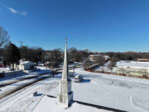
Snow covered steeple of Second New Bethel
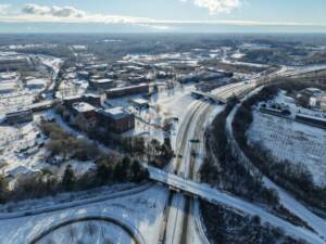
Ariel View Looking Southeast at Salem Parkway and WSSU
